Integrated Marine Information System (IMIS)
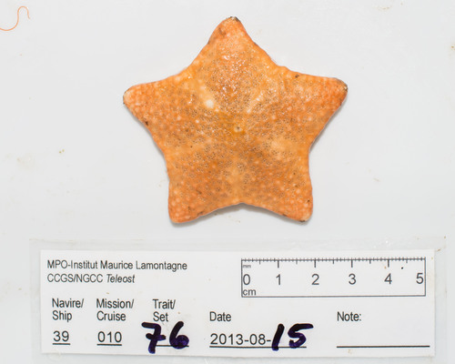
Persons | Institutes | Publications | Projects | DatasetsPoraniomorpha - aboral view
Description Sea star collected on a DFO Quebec Region bottom trawl survey in the Northern Gulf of St. Lawrence.
JPG file - 529.10 kB - 3 021 x 2 417 pixels
Extra information
FileName: 148080.jpg
FileDateTime: 1622254788
FileSize: 529100
FileType: 2
MimeType: image/jpeg
SectionsFound: ANY_TAG, IFD0, THUMBNAIL, EXIF, GPS
COMPUTED.html: width="3021" height="2417"
COMPUTED.Height: 2417
COMPUTED.Width: 3021
COMPUTED.IsColor: 1
COMPUTED.ByteOrderMotorola: 0
COMPUTED.ApertureFNumber: f/8.0
COMPUTED.Thumbnail.FileType: 2
COMPUTED.Thumbnail.MimeType: image/jpeg
Make: PENTAX
Model: PENTAX K-5
XResolution: 150/1
YResolution: 150/1
ResolutionUnit: 2
Software: Adobe Photoshop Lightroom Classic 10.2 (Macintosh)
DateTime: 2021:05:28 22:16:15
Artist: Claude_Nozeres
Exif_IFD_Pointer: 258
GPS_IFD_Pointer: 754
ExposureTime: 1/60
FNumber: 8/1
ExposureProgram: 3
ISOSpeedRatings: 200
ExifVersion: 0231
DateTimeOriginal: 2013:08:15 01:17:29
DateTimeDigitized: 2013:08:15 01:17:29
ShutterSpeedValue: 5906891/1000000
ApertureValue: 6/1
ExposureBiasValue: 0/10
MeteringMode: 5
Flash: 9
FocalLength: 3500/100
ColorSpace: 1
SensingMethod: 2
FocalLengthIn35mmFilm: 52
Contrast: 2
Sharpness: 2
SubjectDistanceRange: 1
GPSLatitudeRef: N
GPSLatitude.0: 48/1
GPSLatitude.1: 311100000/10000000
GPSLatitude.2: 0/1
GPSLongitudeRef: W
GPSLongitude.0: 61/1
GPSLongitude.1: 409500000/10000000
GPSLongitude.2: 0/1
GPSAltitude: 423/1
Location
added on 2021-05-291 116 views
FileName: 148080.jpg
FileDateTime: 1622254788
FileSize: 529100
FileType: 2
MimeType: image/jpeg
SectionsFound: ANY_TAG, IFD0, THUMBNAIL, EXIF, GPS
COMPUTED.html: width="3021" height="2417"
COMPUTED.Height: 2417
COMPUTED.Width: 3021
COMPUTED.IsColor: 1
COMPUTED.ByteOrderMotorola: 0
COMPUTED.ApertureFNumber: f/8.0
COMPUTED.Thumbnail.FileType: 2
COMPUTED.Thumbnail.MimeType: image/jpeg
Make: PENTAX
Model: PENTAX K-5
XResolution: 150/1
YResolution: 150/1
ResolutionUnit: 2
Software: Adobe Photoshop Lightroom Classic 10.2 (Macintosh)
DateTime: 2021:05:28 22:16:15
Artist: Claude_Nozeres
Exif_IFD_Pointer: 258
GPS_IFD_Pointer: 754
ExposureTime: 1/60
FNumber: 8/1
ExposureProgram: 3
ISOSpeedRatings: 200
ExifVersion: 0231
DateTimeOriginal: 2013:08:15 01:17:29
DateTimeDigitized: 2013:08:15 01:17:29
ShutterSpeedValue: 5906891/1000000
ApertureValue: 6/1
ExposureBiasValue: 0/10
MeteringMode: 5
Flash: 9
FocalLength: 3500/100
ColorSpace: 1
SensingMethod: 2
FocalLengthIn35mmFilm: 52
Contrast: 2
Sharpness: 2
SubjectDistanceRange: 1
GPSLatitudeRef: N
GPSLatitude.0: 48/1
GPSLatitude.1: 311100000/10000000
GPSLatitude.2: 0/1
GPSLongitudeRef: W
GPSLongitude.0: 61/1
GPSLongitude.1: 409500000/10000000
GPSLongitude.2: 0/1
GPSAltitude: 423/1
Location
Click here to return to the thumbnails overview
